Constanta Port
The Constanța maritime port cluster includes three areas, of which 2 main ports:
- The port of Constanța, with a total length of quays of 31 km and depths between 7 and 19 m, which allowed the access of oil tankers of 165,000 dwt and bulk carriers of 200,000 dwt and which operates all categories of goods – general solid liquid bulk, goods. , containers, Ro-Ro and oversized and special cargo
- The Port of Midia with a quay length of 2.43 km and a maximum depth of 8m, designed to serve mainly the chemical and petrochemical industry in the area, but which has developed facilities for new categories of goods: LPG, bulk agricultural products, live animals . and metal products
- Basarabi Port, a smaller port, with an area of 11.4 ha, of which 0.7 ha is water
It is joined by Mangalia port with 524 m quay and 9 m maximum water depth, which handles bitumen, general cargo and LPG.
Constanța Port, the largest port on the Black Sea, benefits of complexe competitive advantages:
Favorable geographical position:
Strategically located, it facilitates the transit and international transportation of goods, serving as a nodal point in the region.
Multimodal connectivity:
Extensive hinterland and foreland connections, interconnecting all modes of transport: rail, road, river and pipelines.
Integral part of the European Ten-T network: Connected to the IV multimodal corridor and the VII Rhine-Danube corridor via the Danube-Black Sea Canal, providing direct access to the global maritime transport network.
Strategic alternative for goods flows from Central Asia and the Far East: Facilitates international trade through the Middle Corridor, on the Caspian Sea – Black Sea route.
Modern infrastructure and facilities:
Specialized terminals and logistics centers for containers, grain, oil and other bulk cargoes, general cargo, Ro-Ro and bulk cargo, as well as modern passenger ship facilities.
High water depth (up to 19 m): Allows the berthing of the largest ships passing through the Suez Canal, large-capacity tankers and ore, reducing transport costs and increasing logistics efficiency.
Large operating capacity: With an annual capacity of approximately 120 million tons and 156 berths (of which 140 are operational), the port is constantly developing and modernizing.
Modern terminals for agricultural goods, fully automated, facilitating the export of grains from Central and Eastern Europe and consolidating the Port of Constanța as the gateway to global markets, via the Black Sea.
The largest container terminal in the Black Sea basin, with a processing capacity of 1,000,000 containers per year, which ranks it as the most important logistics hub in the Black Sea.
A new RO-RO terminal for up to 80,000 vehicles per year that facilitates efficient transport between European countries and the markets of Turkey and Central Asia.
A new oil terminal under development that expands oil product handling capabilities, including for biofuel, contributing to diversification and alignment with EU supply requirements and green energy transition.
Free Zone Status:
Tax and customs benefits that facilitate trade and transit of goods within the European Union.
These characteristics give Constanța Port a major competitive potential in the Black Sea region and position it as an essential logistics hub for international trade.
TRAFFIC OF GOODS IN THE PORT OF CONSTANTA. EVOLUTION AND TRENDS
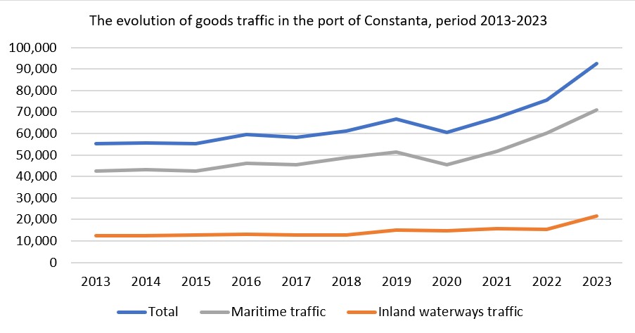
Investments in operating capacities, the modernization and efficiency of maritime and naval services, in synergy with the trends dictated by economic and political factors, have attracted new volumes of goods, with port traffic registering a constant increase from year to year, according to the following:
In 2023, port traffic reached 92.69 million tons of operated goods, recording an increase of 22.7% compared to the total traffic in 2022 and over 37% compared to 2021 and reflecting the upward trend of the last decade of port activity.